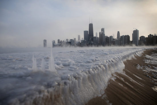
Lake Michigan ice as temperatures plunged to -16 deg. F in Chicago, IL on Jan. 6, 2014.
The low temperature on Wednesday, January 30, 2019 could approach -30 deg F in the Chicago suburbs. (Getty Images)
A “Siberian Express” weather disturbance currently crossing the Arctic Ocean will meet up with the semi-permanent winter “polar vortex” over Canada, pushing a record-breaking cold air mass into the Upper Plains and Midwest U.S. by Wednesday.
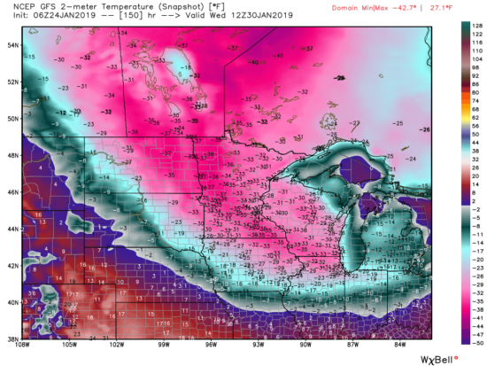
Chicago All-Time Record Low? Both the European (ECMWF) and U.S. (GFS) weather forecast models are in agreement that by Wednesday morning temperatures in the Chicago suburbs will be approaching -30 deg. F. The all-time official record low for the Chicago metro area was -27 deg. F (O’Hare) on January 20, 1985, and that 34 year old record could fall as the ECMWF model is forecasting -32 deg. F for Thursday morning while the GFS model is bottoming out at -26 deg. F on Wednesday morning. Of course, these forecasts will change somewhat in the coming days as the cold wave approaches.
Dangerous Wind Chills Like the record-breaking event of January 1985, the frigid temperatures will be accompanied by strong winds — gusting to 20 to 30 mph — with wind chills plunging to -60 deg. F at times. This is dangerously cold, and I suspect schools will close, water lines will freeze, and travel will be discouraged. Again, this event is still several days away, but the public should be aware of the potential severity of this cold wave.
Not Just Chicago The GFS forecast temperatures for Wednesday morning shows most of the upper Midwest will be well below zero, and temperatures might not get above -20 deg. F even at midday on Wednesday as far south as northern Indiana. Again, the strong northwest winds will be pushing this air southeast, and Thursday morning will also bring record-breaking cold into the Ohio River Valley.
Forecast temperatures Wednesday morning, January 30, 2019 from the GFS model.
(Graphic courtesy of WeatherBell.com).
I recorded -28F on my thermometer last night. Forecast temp for next Monday is 52F. If that happens, comes close it will be around an 80degree temp swing in under a week! Gotta love the upper midwest!
On the way up the lift my fellow passengers said they wanted to take a picture from up top. I warned them there wasn’t a lot of good photo opportunities. “But every time I look at that ugly lake, it reminds me of me!”
We got a little snow. More coming. The view up the hill from my front door. It’s my only door, but you can climb out my bedroom if you can get the window open. Wink, wink ladies. “But I’m a creep. I’m a weirdo...”
I think it’s been about 8-9 feet this week here. Got a bunch of rain for half a day a couple days ago. It’s like a slip and slide on any slopes for the cars here.